Support Site Support Site

  • Support Home
    • Support Home
    • MapCast Support
  • Company Home
  • Service Sites
    • MapCast
    • MapWarehouse
    • VuMAP
  • Contact
Home / 1. Pre-Sales, 8. Data / What spectral bands are available in satellite imagery?

What spectral bands are available in satellite imagery?

660 views Less than a minute

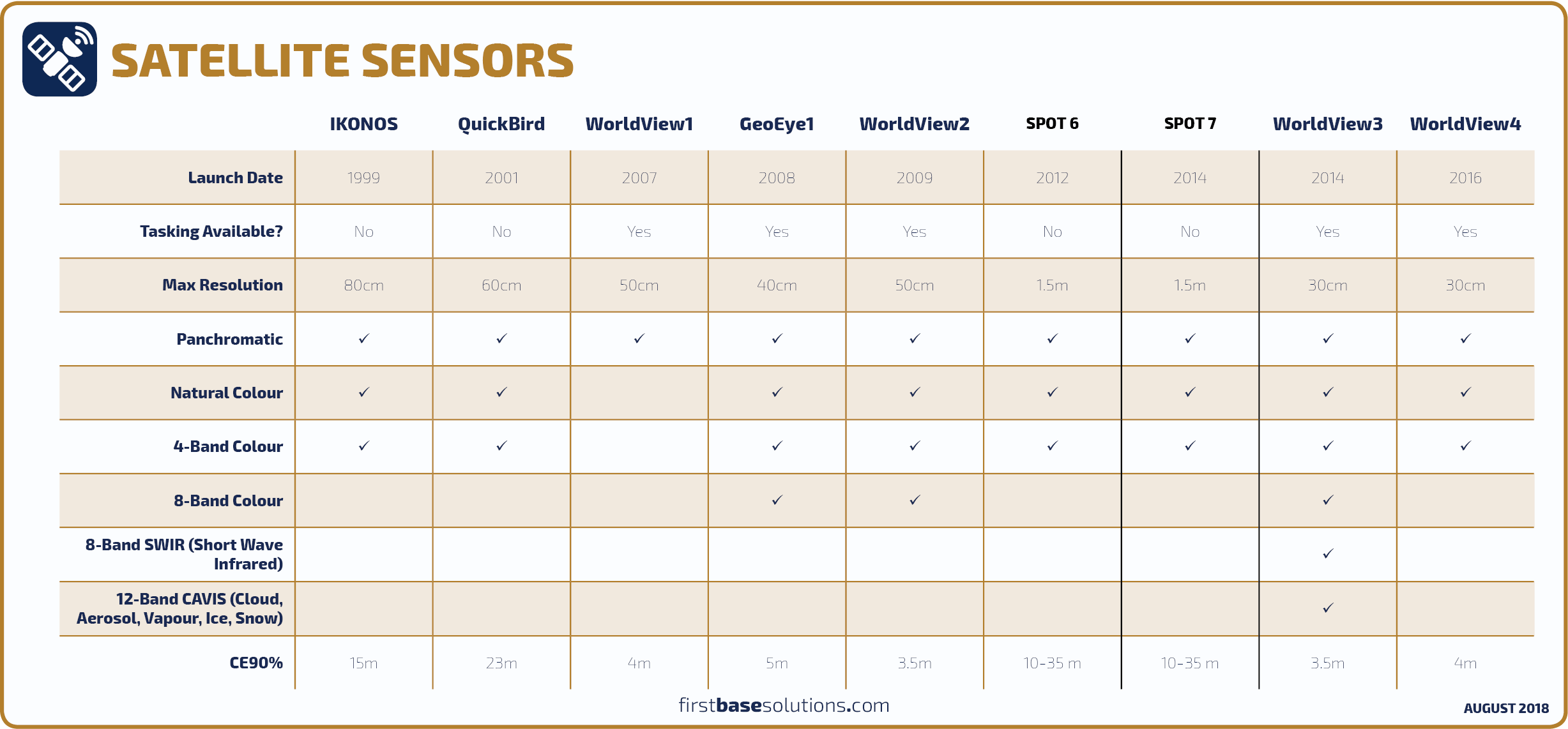
Each sensor vehicle captures imagery with slightly different spectral ranges and capabilities. Imagery can be ordered as panchromatic (grayscale), natural colour (R-G-B), false colour infrared (IR-R-G), 8-band (includes additional radiation in both ultraviolet and infrared ends of the spectrum) and SWIR (short wave infrared).

8 bandCIRcustom orderdigitalglobeGeoEyeMaxarplanet labssatelliteSPOTWorldView 1. Pre-Sales8. Data

Related Articles

  • What Can I Do With 8 Band Imagery?
  • What’s EPSG And How Do I Use It?
  • Does the surface type affect the accuracy of LiDAR?
  • Can PIN data be purchased in a tabular format?

Search Everything

FAQ’s

CAD (13) Data (54) Elevations (23) Flood Line (10) Groundwater (5) LiDAR (2) MapCast (15) MapWarehouse (38) Ontario Base Mapping (16) Orthophoto (34) Parcels (15) Post-Sales (35) Pre-Sales (49) Sales (24) Satellite (13) Troubelshooting (20) Tutorial (14) VuMAP (15)

Article Categories

  • 401. Pre-Sales
  • 252. Sales
  • 293. Post-Sales
  • 94. MapCast
  • 135. MapWarehouse
  • 106. VuMap
  • 27. News
  • 598. Data
  • 79. My Account
  • 3VuMap Help

First Base Solutions

140 Renfrew Dr, Suite 100
Markham, ON L3R 6B3
905-477-3600
www.firstbasesolutions.com

Keep Looking

Follow

2020 © First Base Solutions Inc.
  • Support Home
  • Corporate Home