VuMap Provides users with two tools to view the attributes of the layers within VuMap. The first tool is the simple Query by Point tool which allows the user to click on a single point on the map and retrieve all the attributes for all the layers that are currently on that intersect with the point. The second tool is the Select Data tool which allow the users to draw a shape on the map and retrieve the attributes for a selected layer which intersect with the drawing
Using the Query Tool
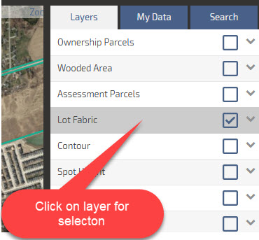
- First in the Layers panel turn on the layers that you would like to query
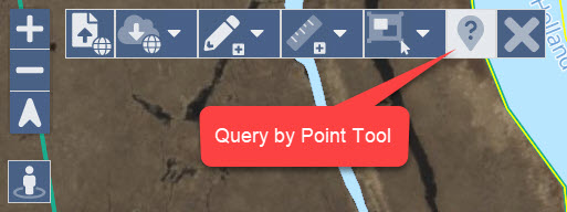
- Next, select the Query Tool from the tool bar menu at the top of the map interface
![]()
Select the query tool - To perform the query simply click on the map. The attributes for all active layers will be displayed in a Query Results table. To view multiple results simply scroll down. Individual results can be highlighted by mousing over the layer name in the Query Results table.
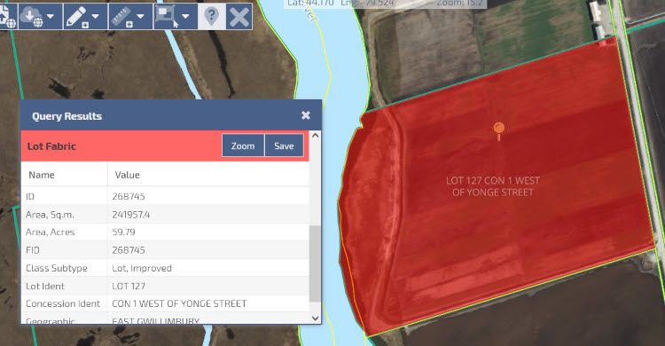
Query Results Table - To save your query results click on the Save button in the Query Results table. The application will automatically add the information to your My Data panel, you then can enter a name to for the new layer, change the colours and apply a label using one of the attributes.
Selecting Data
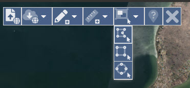
The date Selection tools allow the user to view multiple features from a single layer based on a shape drawn by the user. We offer three shape types the user can draw, rectangle, free form polygon and circle. The application is limited to return a maximum of 1000 features per query.
- To begin turn on the layer you would like to query in the Layers menu on the right side of the application. You must then click on the layer to highlight it.
Turn on the layer and select the layer to highlight it to perform the selection - Next, from the toolbar open the Select Features menu and select the type of shape you would like to draw to perform the selection; freehand polygon, rectangle or circle.
Select the selection drawing type from the tool bar menu - After choosing a drawing type outline the area you would like to query on the map interface. If you are performing a free hand drawing double click to complete the drawing
- Once complete the application will display the intersecting features in the Results table at the bottom of the application.
Individual selected features can be highlighted on the map by clicking on the feature in the table.You have the option to sort the selected features