Support Site Support Site

  • Support Home
    • Support Home
    • MapCast Support
  • Company Home
  • Service Sites
    • MapCast
    • MapWarehouse
    • VuMAP
  • Contact
Home / VuMap Help / Layers

Layers

1648 views Less than a minute

Layer Control Tab

TEST

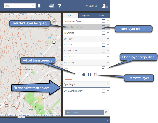
VuMap provides users with a set of predefined layers based on your subscription, these layers can include parcel information, imagery layers and various open source datasets. The controls for these layers are listed in the “Layers” widget on the right side of your VuMap interface and will allow users to:

  • Turn layers on or off in the map interface
  • Highlight a layer to perform queries or selections on. To highlight a layer simply click on the layer
  • Reorder the layers by dragging and dropping the layers. Note that VuMap separates layers into raster (image based data) or vector (geometry based data) layers, raster layers cannot be placed on top of vector layers
  • Remove layers from the list to simplify you view and keep only the layers you need, removed layers can be added again using the user administration

The layer controls and properties. Note that the layer style cannot be modified for purchased layers

VuMap Help

Search Everything

FAQ’s

CAD (13) Data (54) Elevations (23) Flood Line (10) Groundwater (5) LiDAR (2) MapCast (15) MapWarehouse (38) Ontario Base Mapping (16) Orthophoto (34) Parcels (15) Post-Sales (35) Pre-Sales (49) Sales (24) Satellite (13) Troubelshooting (20) Tutorial (14) VuMAP (15)

Article Categories

  • 401. Pre-Sales
  • 252. Sales
  • 293. Post-Sales
  • 94. MapCast
  • 135. MapWarehouse
  • 106. VuMap
  • 27. News
  • 598. Data
  • 79. My Account
  • 3VuMap Help

First Base Solutions

140 Renfrew Dr, Suite 100
Markham, ON L3R 6B3
905-477-3600
www.firstbasesolutions.com

Keep Looking

Follow

2020 © First Base Solutions Inc.
  • Support Home
  • Corporate Home