Support Site Support Site

  • Support Home
    • Support Home
    • MapCast Support
  • Company Home
  • Service Sites
    • MapCast
    • MapWarehouse
    • VuMAP
  • Contact
Home / 1. Pre-Sales, 8. Data / How is flood mapping different from other elevation maps?

How is flood mapping different from other elevation maps?

709 views Less than a minute

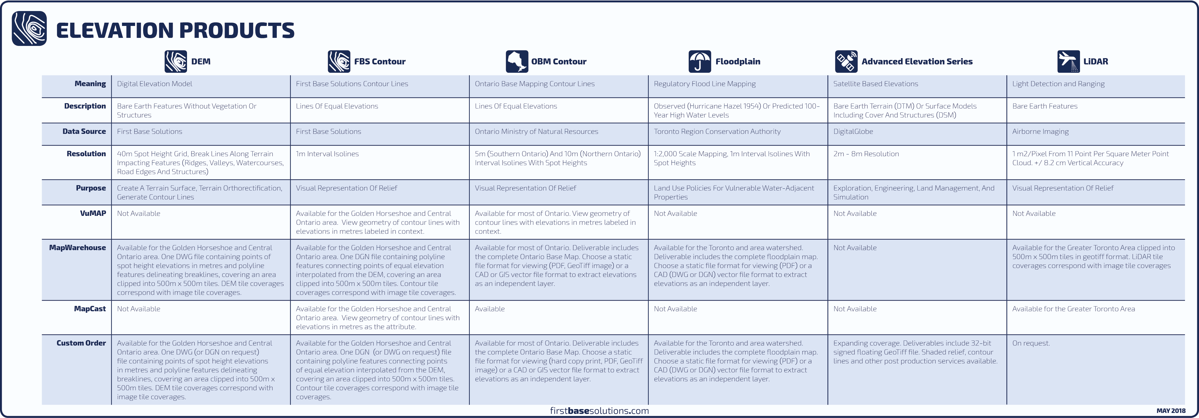
Other elevation models are simply a record of the elevations across an area. Modeling and flooding predictions made by any agency other than the Conservation Authority are of no regulatory effect. The hydraulic analysis performed by the Conservation Authority takes into account not just the volumetric limitations of a stream corridor, but also site specific characteristics such as soil types, and impervious material like rooftops and asphalt, which affect the rate at which a watershed can discharge surplus water and return to normal flow. The floodplain map alone can be considered an administrative tool.

contoursDEMDTMElevationfile formatsfloodmetadataontario base mappingtopo 1. Pre-Sales8. Data

Related Articles

  • What Can I Do With 8 Band Imagery?
  • What’s EPSG And How Do I Use It?
  • Does the surface type affect the accuracy of LiDAR?
  • Can PIN data be purchased in a tabular format?

Search Everything

FAQ’s

CAD (13) Data (54) Elevations (23) Flood Line (10) Groundwater (5) LiDAR (2) MapCast (15) MapWarehouse (38) Ontario Base Mapping (16) Orthophoto (34) Parcels (15) Post-Sales (35) Pre-Sales (49) Sales (24) Satellite (13) Troubelshooting (20) Tutorial (14) VuMAP (15)

Article Categories

  • 401. Pre-Sales
  • 252. Sales
  • 293. Post-Sales
  • 94. MapCast
  • 135. MapWarehouse
  • 106. VuMap
  • 27. News
  • 598. Data
  • 79. My Account
  • 3VuMap Help

First Base Solutions

140 Renfrew Dr, Suite 100
Markham, ON L3R 6B3
905-477-3600
www.firstbasesolutions.com

Keep Looking

Follow

2020 © First Base Solutions Inc.
  • Support Home
  • Corporate Home