Support Site Support Site

  • Support Home
    • Support Home
    • MapCast Support
  • Company Home
  • Service Sites
    • MapCast
    • MapWarehouse
    • VuMAP
  • Contact
Home / 1. Pre-Sales / What Are You Planning To Do With It?

What Are You Planning To Do With It?

1398 views Less than a minute

The first question I often ask when a brand new potential customer calls looking for aerial imagery is, “What’s it for?”

To make our mapping products more accessible to the first time user, your answer will usually fall into one of these categories:

  1. To analyze vegetation health in canopies or crops.
  2. To add a photo base layer for context in my GIS or CAD project.
  3. To extract elevation data.
  4. To compile a new map together with existing data.
  5. To digitize vector features from imagery.
  6. To research land or property information.
  7. To market real estate.

With your end goal in mind, follow the decision chart below to estimate what types of data you need and the best way to get it.
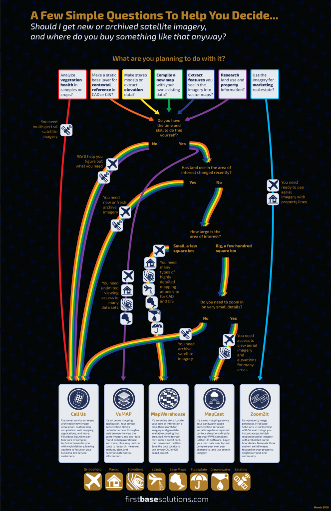
What are you planning to do with it?
datadecision supportflowchartgetting startedworkflow 1. Pre-Sales

Search Everything

FAQ’s

CAD (13) Data (54) Elevations (23) Flood Line (10) Groundwater (5) LiDAR (2) MapCast (15) MapWarehouse (38) Ontario Base Mapping (16) Orthophoto (34) Parcels (15) Post-Sales (35) Pre-Sales (49) Sales (24) Satellite (13) Troubelshooting (20) Tutorial (14) VuMAP (15)

Article Categories

  • 401. Pre-Sales
  • 252. Sales
  • 293. Post-Sales
  • 94. MapCast
  • 135. MapWarehouse
  • 106. VuMap
  • 27. News
  • 598. Data
  • 79. My Account
  • 3VuMap Help

First Base Solutions

140 Renfrew Dr, Suite 100
Markham, ON L3R 6B3
905-477-3600
www.firstbasesolutions.com

Keep Looking

Follow

2020 © First Base Solutions Inc.
  • Support Home
  • Corporate Home